There are plenty of moderately challenging Vancouver hiking trails to choose from. These are five trails that stand out from the rest. Not too difficult, yet all have sensational views. Hollyburn, Dog Mountain and Mt Seymour are at the end of beautiful drives to reach the trailheads.
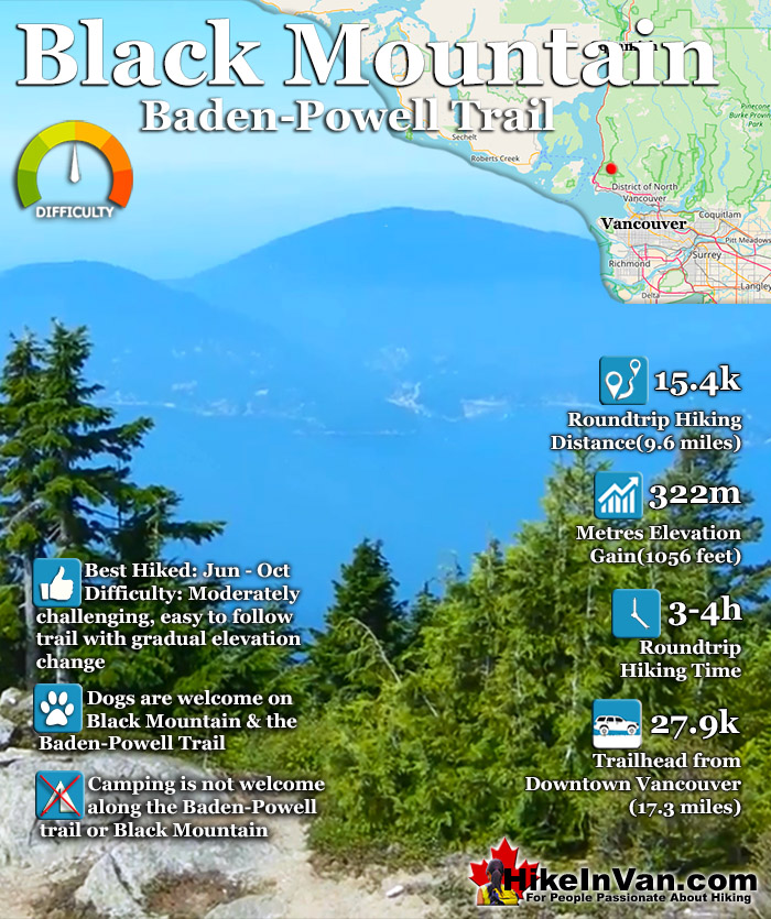
Black Mountain can be reached from two different trailheads. The trailhead from Cypress Resort and the original trail off Marine Drive halfway between Horseshoe Bay and Lighthouse Park. The trailhead south of Horseshoe Bay is a challenging 19 kilometre roundtrip hike but fantastically scenic. This route follows the Trans Canada Trail for about 20 minutes before branching off toward, then past Whyte Lake.
The Cypress Mountain Resort is the newer, shorter and easier way to access Black Mountain and Eagle Bluffs. Located just a short and very nice, 30 minute drive from downtown Vancouver, the Black Mountain and Eagle Bluffs trail begins next to the Cypress Mountain Resort chairlifts. The well marked trail branches away from the chairlift to the left and quickly ascends into the deep and beautiful forest. Follow the clear signs to Eagle Bluffs. The route can be done in a circle route, so try to take the other route on the way back for variety. Black Mountain is a short side trail off this circle route. Allow yourself 3-4 hours for the 7.7k return trip to both Black Mountain and Eagle Bluffs. The elevation gain is 350m in 4k. Expect to need snowshoes December to May. During these months use caution as snow may obscure the trail markers and combined with bad weather can very easily make you lose the trail. The Cypress Mountain trailhead and parking for Black Mountain and Eagle Bluffs is also the gateway to the amazing Howe Sound Crest Trail. This amazing trail in Cypress Provincial Park extends north from the Cypress Resort parking and ascends deep into the North Shore Mountains. Mount Strachan, St Mark`s Summit, Unnecessary Mountain and The Lions are all accessible from this trailhead.
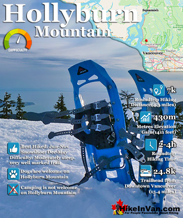
Continuing north beyond The Lions, the Howe Sound Crest Trail leads to Mount Harvey, Mount Hanover, Brunswick Mountain and finally Deeks Peak. Hollyburn Mountain is another wonderful hiking trail near the Cypress Mountain, Black Mountain trailhead. Located at the Cypress Mountain cross country skiing area the trailhead to Hollyburn Mountain is marked with a large mapboard. Hollyburn Mountain is an easy, 7 kilometre roundtrip hike to fantastic views of Vancouver.
Black Mountain View of Mount Baker
Black Mountain Cypress Trailhead
The Eagle Bluffs and Black Mountain trailhead is very easy to find. It is found at Cypress Mountain Resort in West Vancouver (free parking and free to use the trails). From downtown Vancouver follow the signs across the Lions Gate Bridge as if you were going to Whistler on the Sea to Sky Highway. From Sea to Sky Highway #99 (aka Highway #1), about 10 minutes from the Lions Gate Bridge take the #8 Exit to Cypress Provincial Park. There are clear signs on the highway for this exit so you can't miss it. Follow Cypress Bowl Rd almost to Cypress Mountain Resort. Follow this road all the way to the end and park at the Cypress Mountain Resort Ski area. You will see a large wooden map board showing trails in the Cypress Mountain area. You will see on this board the trail leading to Eagle Bluff and Black Mountain. You will need to walk toward the nearby chairlift and follow the trail leading into the trees on the left side and clear trail markers and signs from there.
Black Mountain Trans Canada(Lower) Trailhead
From Vancouver take Exit 2 for Eagleridge Drive, then left on Marine Drive. Just past the marina, turn left on Cranley Drive. Look for the sign for the Trans Canada Trail about 500 metres from Marine Drive. From here follow the Trans Canada Trail signs that take you under the Highway. Continue following the Trans Canada Trail for about 20 minutes until you come to a junction. The Trans Canada Trail goes right, however, follow the trail going left and take the bridge where you follow Whyte Creek. Soon you will see Whyte Lake on your right, at the next fork in the trail, bear right and this will lead to the well marked trail to Eagle Bluffs and then Black Mountain.
Explore Vancouver Hiking Trails!
Hollyburn Mountain in Cypress Provincial Park, is an amazing hiking and snowshoeing trail. The Hollyburn trailhead is an astonishingly close, 30 minute drive from downtown Vancouver. The 30 minutes is quite ...
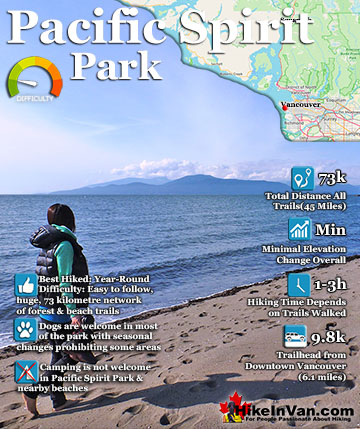
Pacific Spirit Park surrounds the University of British Columbia on the shores of Georgia Straight. The park has a beautiful array of trails, 73 kilometres in total, that run along beaches, some old growth forest ...
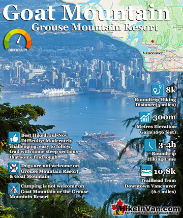
Goat Mountain is a beautiful mountain to hike from Grouse Mountain. It is challenging at times but fairly relaxing overall. It is just 4k from the Grouse Mountain Chalet and should only take 3-4 hours ...
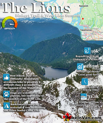
The Lions or Twin Sisters lie in North Vancouver, south of Squamish. The two distinct, rocky peaks are visible from downtown Vancouver and, though hard to believe, the West Lion summit can be climbed. You ...
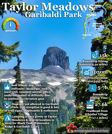
Taylor Meadows is a beautiful campsite and alternative to the much busier and more well known, Garibaldi Lake campsite. Located in between Garibaldi Lake and Black Tusk itself. It is reached from the same ...
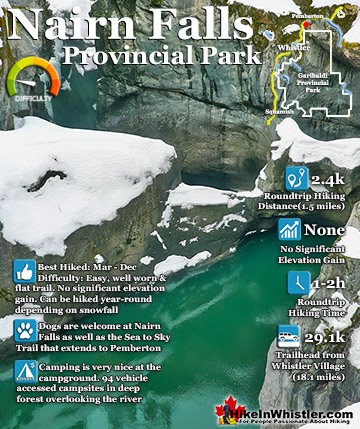
Nairn Falls is a swirling, crashing and chaotic waterfall that surrounds you from the deluxe viewing platform that allows you to safely watch it from above. The beautiful, green water rushes through the deep and ...
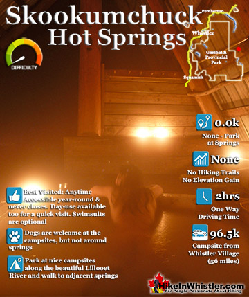
Skookumchuck Hot Springs (aka: T'sek Hot Springs and St Agnes Well Hot Springs) is located two hours north of Whistler along the edge of Lillooet River. The name Skookumchuck means "strong water" in the ...
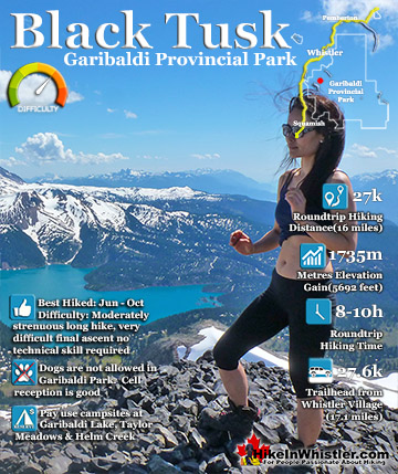
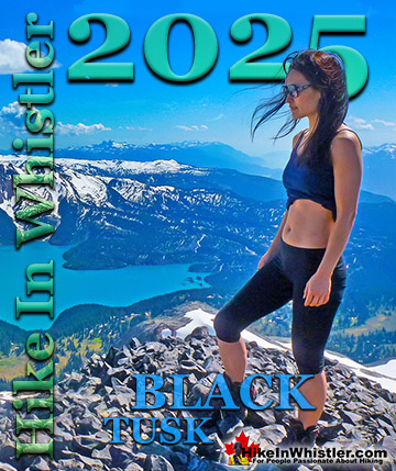
Black Tusk is the extraordinarily iconic and appropriately named mountain that can be seen from almost everywhere in Whistler. The massive black spire of crumbling rock juts out of the earth in an incredibly ...
Whistler is an amazing place to hike. Looking at a map of Whistler you see an extraordinary spider web of hiking trails. Easy trails, moderate trails and challenging hiking trails are all available. Another marvellous thing about Whistler is that Garibaldi Provincial ...
Squamish sits in the midst of some amazing places to hike. Garibaldi Park sprawls from Squamish up and beyond Whistler. Tantalus Provincial Park lays across the valley to the west and the beautiful and desolate, by comparison, Callaghan Valley to the north. Add to ...
Clayoquot Sound has a staggering array of hiking trails within it. Between Tofino and Ucluelet, Pacific Rim Park has several wilderness and beach trails, each one radically different from the last. The islands in the area are often Provincial parks on their own with ...
Victoria has a seemingly endless number of amazing hiking trails. Most take you to wild and beautiful Pacific Ocean views and others take you to tranquil lakes in beautiful BC Coastal Rainforest wilderness. Regional Parks and Provincial Parks are everywhere you turn ...
The West Coast Trail was created after decades of brutal and costly shipwrecks occurred along the West Coast of Vancouver Island. One shipwreck in particular was so horrific, tragic and unbelievable that it forced the creation of a trail along the coast, which ...