There are plenty of moderately challenging Vancouver hiking trails to choose from. These are five trails that stand out from the rest. Not too difficult, yet all have sensational views. Hollyburn, Dog Mountain and Mt Seymour are at the end of beautiful drives to reach the trailheads.
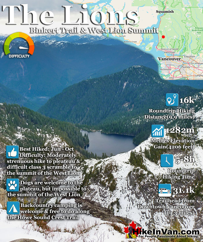
The Lions or Twin Sisters lie in North Vancouver, south of Squamish. The two distinct, rocky peaks are visible from downtown Vancouver and, though hard to believe, the West Lion summit can be climbed. You don't have to, however, as the plateau before this difficult summit has amazing views. In fact, most finish their hike to The Lions at the wonderful plateau close to the West Lion and looking across to the East Lion.
It is beautiful enough, tough, and very rewarding to get to this plateau. To get to the West Lions summit is considerably more challenging and comparatively more rewarding. The view from the top of the West Lion is spectacular. Howe Sound stretches out into the blue distance. A tough but wonderful hike in easy conditions. In wet, cold, or snowy weather, a summit attempt is very treacherous. Not only is cold, snowy, icy or wet weather a consideration due to the slippery footing and hand holds, but also cloudy and foggy weather. Fog can reduce visibility enough to make finding your way, and more importantly, finding your return route, difficult to find. Losing your way from the top of the West Lion has proven fatal in the past. The first half of the Lions Binkert Trail is very easy as you follow a disused, though beautifully overgrown logging road gently uphill. After the first 30 minutes of hiking you come to a Y junction, take the path on the right and continue as the path eventually narrows and beautiful views of Howe Sound become visible. You will pass two waterfalls, then come to a sign (The Lions>>) that blocks the old, very overgrown logging road and points to a narrow path to the right. You will cross Harvey Creek over a beautiful little bridge with wonderful views, then the first significant uphill hiking starts. From this point on the trail is very well marked with flagging tape, tree markers and paint indicators on the rock faces.
The Lions Binkert Trail Harvey Creek Bridge
The Lions from St Mark's Summit
The Binkert Trail to the West Lion Summit
There are two plateaus before the final, very difficult ascent to the summit of the West Lion. Both plateaus have incredible views and most make the second plateau their final destination. It is at the base of the West Lion. There are not really any suitable or marked places to put up a tent, but if you had to choose, somewhere in the vicinity of these two plateaus would be the place to do it. If you continue to the summit be prepared for a four metre rope descent. The ropes are there, fixed to a tree above, but are alarmingly worn. If you have ropes, you may want to bring them for this part. After this, you will cross the narrow col connecting to the West Lion. This very narrow approach has stunning views of Howe Sound framed by cliffs on either side. This begins the difficult, class 3 section. Easy if you are a seasoned climber, though very difficult if you are an average hiker. Keep in mind that going up is not too challenging, however, climbing down is tricky and dangerous. Clinging to narrow rocks and ledges you have to make your way around the right hand side of the steep West Lion. This section is so dangerous that there are permanent ropes fixed in places to prevent you falling several dozens of metres if you lost your grip. There is one section of rope now missing which is a bit unsettling.
The Lions Binkert Trail View of Howe Sound
The Lions Trail View of Black Tusk
The Lions Trail View of Mount Garibaldi
Approaching The Lions
The East Lion summit is in the watershed area and is forbidden to climb. The West Lion is just outside the watershed and climbable. It is however, quite difficult and the wet and cloudy climate make it somewhat dangerous. In September 2006 two climbers after reaching the West Lion Summit and smoking celebratory cigars began their descent. Unfortunately the all-too-common fog of Vancouver had engulfed the mountain and they lost the trail. They reportedly attempted to climb back to the summit and find the ascent trail again, however, at a free climb of a small cliff one of the hikers fell 100 metres to his death. A combination of fog, wet and loose rock holds caused this tragedy. The beautifully visible twin peaks of the Lions were known by the Indigenous Peoples of this part of the world as The Sisters. They are still considered sacred as they are a legal marker of a past peace treaty that ended a war between the Squamish and the Haida tribes. In more recent times they have inspired the naming of the Lions Gate Bridge and the BC Lions football team.
The Lions Up Close
View Alongside the West Lion
Approaching the West Lion
The West Lion Summit Route Ascends Down and Around
West Lion Summit Route Amazing Views
West Lion Final Ascent Route
Steep Climb to the West Lion Summit
West Lion Summit Views Are Sensational
The West Lion Summit Cairn
Looking Down on Enchantment Lake
West Lion Summit View of the East Lion
Trailhead & Parking Directions for The Lions
The trailhead to Brunswick Mountain is tricky to find. It is located town of Lions Bay which is about an hours drive from downtown Vancouver or a half hour south of Squamish. From either direction on the Sea to Sky Highway, take the Lions Bay exit onto Oceanview Road (the 2nd Lions bay exit from either direction), then immediately turn left onto Cross Creek Road, then right onto Centre Road, then left onto Bayview Road, then left onto Mountain Drive, left again onto Sunset Road and park near the black gate at the dead end. Be sure to park legally as they actively tow illegally parked cars. More parking is available at the school 1 kilometre from here. Arrive early to ensure convenient parking. Legal parking is between the two cars pictured here.
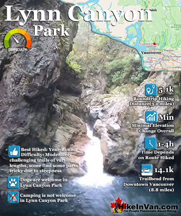
This easy and strikingly beautiful park is yet another locals favourite. So close to downtown Vancouver at only 30 minutes away, yet you feel as if you are in a remote forest. There are a few different ...
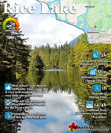
Rice Lake is a relaxing walk around a cute lake in Lynn Valley. It is a family friendly hike although dogs are not welcome. Roundtrip from your car the trail around the lake is just 3 kilometres and should ...
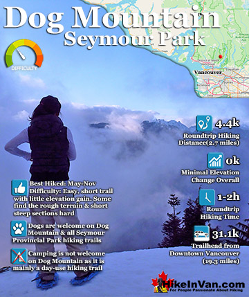
Dog Mountain is a beautiful, short and fun hike (or snowshoe trek) close to Vancouver and starting from the parking lot of Mount Seymour Resort. Just 2.2 kilometres gets you from your car to breathtaking views of ...
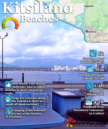
The Kitsilano beaches begin as soon as you cross the Burrard Bridge and enter the residential paradise of Kitsilano. Though only this first beach is named Kitsilano Beach, you can walk from one beach to the next ...
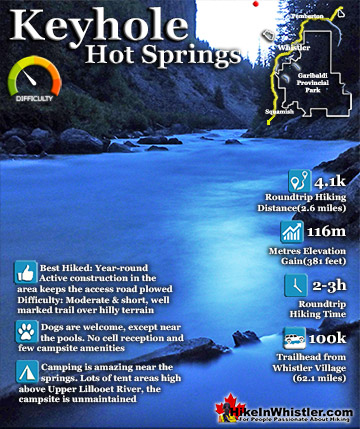
Keyhole Hot Springs(sometimes called Pebble Creek Hot Springs) is located 100 kilometres from Whistler(Village Gate Blvd). Though most of the 100 kilometres is on logging roads, it is driveable by most cars ...
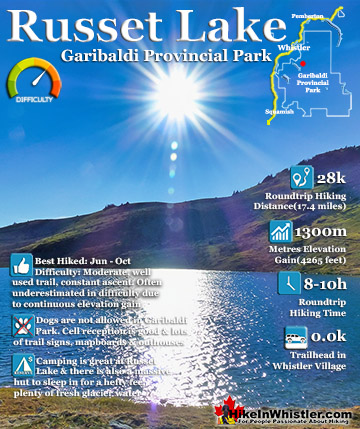
Russet Lake is a surreal little paradise that lays at the base of The Fissile. The Fissile is the strikingly bronze mountain visible from Whistler Village. From the Village look into the distance at the Peak2Peak ...
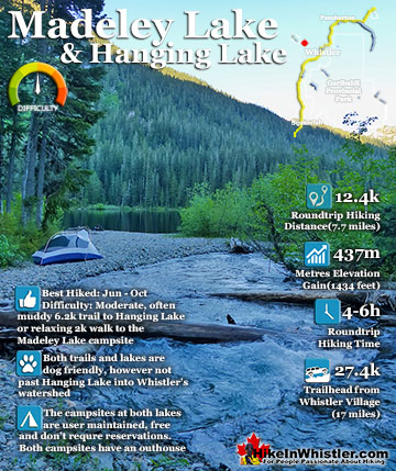
Madeley Lake is a gorgeous lake hidden high up in the wilderness of Callaghan Valley. The Callaghan Valley runs somewhat parallel to Whistler Valley, with the two valleys separated by Mount Sproatt. Sproatt is ...
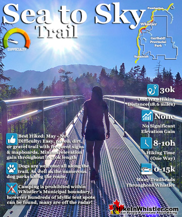
The Sea to Sky Trail is a 180 kilometre multi-use trail that runs from Squamish to D'Arcy. The trail is still under construction in many parts, however, the amazing route through Whistler is finally in ...