There are plenty of moderately challenging Vancouver hiking trails to choose from. These are five trails that stand out from the rest. Not too difficult, yet all have sensational views. Hollyburn, Dog Mountain and Mt Seymour are at the end of beautiful drives to reach the trailheads.
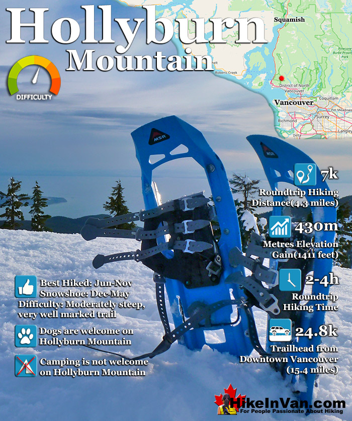
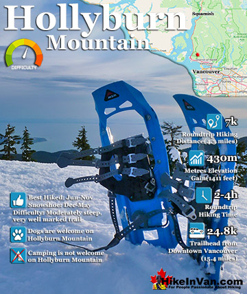
Hollyburn Mountain in Cypress Provincial Park, is an amazing hiking and snowshoeing trail. The Hollyburn trailhead is an astonishingly close, 30 minute drive from downtown Vancouver. The 30 minutes is quite something as well. From the always beautiful crossing of the Lions Gate Bridge, to the incredible views of Vancouver from the approach drive to Cypress Mountain and the Hollyburn Mountain trailhead.
You would almost expect that there would be various fees for parking, trail use, etc. But the Hollyburn Mountain trail is completely free. No charge for parking or trail use. Also, dogs are welcome and you will likely be able to park within a few metres of the trailhead. As if it couldn't get better, it does... the trail is so well marked that it can easily be done after dark, as many do. What a perfect escape from the city. A perfect mountain escape to a towering mountain paradise far above the big city below. The city lights are amazing. From the lights of the Lions Gate Bridge, to the beautifully bright tankers, to the wondrously glowing Vancouver towers. This hike has it all. Great views, easy hike, convenient times to use, and of course free. Hiking or snowshoeing Hollyburn Mountain is yet another spectacular piece of the whole amazing Vancouver experience. Hollyburn Mountain is easily done in a half day trip from Vancouver as it is quite close and quite a short hike/snowshoe, at only 7k roundtrip. Go early for the amazing sunrise, or late in the day for the unbelievable sunset. The Hollyburn Mountain trail is very well marked with light reflecting, neon orange, 6 foot tall marker poles, only a few metres apart most of the way. Though the trail is a fairly constant uphill it is a relatively short trail. Most make it to the summit of Hollyburn in an hour from the trailhead. Coming down is quite a bit faster and you will see people using crazy carpets on the trail in the winter. In the summer with no snow, your downward pace will be quite fast as compared to uphill. If you plan to hike or snowshoe Hollyburn Mountain after dark, make sure you have a light and a backup light. The trail marker poles only reflect light, so you could easily lose the trail without lights after dark.
Hollyburn Mountain Summit Views
The amazing views from the summit of Hollyburn Mountain include, the Lions Gate Bridge, Vancouver, West Vancouver, Howe Sound and Georgia Straight, the Lions, and quite a lot else. Hollyburn Mountain is one of the highest around and the view is a panoramic 360. The drive to and from Hollyburn Mountain is amazing. If you are not too excited about hiking or snowshoeing, the drive alone is well worth it. There are a couple great places to stop on the drive up. Both have nice parking areas perched on the edge of the mountain along the road. Picnic tables and nice information boards to go with the spectacular views.
Cypress Mountain's Hollyburn Live Webcam
Cypress Mountain's Live Olympic Plaza Cam
Trailhead Directions to Hollyburn Mountain
The Hollyburn Mountain trailhead is very easy to find. It is found at the cross country skiing area of Cypress Mountain Resort in West Vancouver. From downtown Vancouver follow the signs across the Lions Gate Bridge as if you were going to Whistler. From Highway #1/Sea to Sky Highway #99, about 10 minutes from the Lions Gate Bridge take the #8 Exit to Cypress Provincial Park. There are clear signs on the highway for this exit so you can't miss it. Follow Cypress Bowl Rd almost to Cypress Mountain Resort. As you near the resort you will see a huge sign on your right directing you to the "Cross-Country Skiing Area". Turn right here and drive for about 100 metres and you will see parking, and on the left side you will see big wooden map kiosk and the hiking/snowshoeing trail head up to the left, running parallel to the huge power lines. There is lots of free parking, washrooms and a snack store as well as snowshoe rentals here.
Explore Vancouver Hiking Trails!
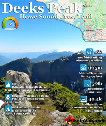
Deeks Peak is at the far north end of the beautiful Howe Sound Crest Trail which runs from Cypress Resort 29k away. The trailhead near Porteau Cove is the access point Deeks Peak and Deeks Lake. It is a ...
Hollyburn Mountain in Cypress Provincial Park, is an amazing hiking and snowshoeing trail. The Hollyburn trailhead is an astonishingly close, 30 minute drive from downtown Vancouver. The 30 minutes is quite ...
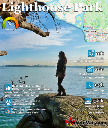
Lighthouse Park is an extraordinarily little know piece of paradise, so close to to Vancouver as to see its tall buildings, yet immersed into a dramatically beautiful coastal rainforest. A wonderful network ...
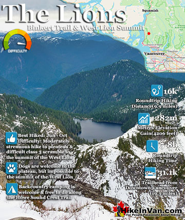
The Lions or Twin Sisters lie in North Vancouver, south of Squamish. The two distinct, rocky peaks are visible from downtown Vancouver and, though hard to believe, the West Lion summit can be climbed. You ...
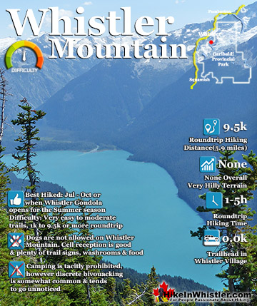
The alpine hiking trails on Whistler Mountain are the ultimate in luxurious hiking. Little hiking effort gets you amazing views of turquoise lakes, snowy mountain, valleys of flowers, waterfalls and spectacular ...
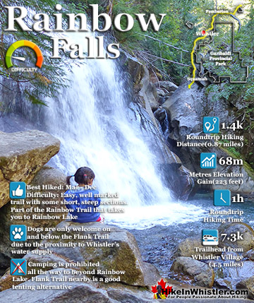
The short, scenic and easy hiking trail to Rainbow Falls is found at the same, much more well known trailhead for Rainbow Lake. The trailhead is marked as the Rainbow Trail and the trail quickly ascends ...
Whistler is an amazing place to hike. Looking at a map of Whistler you see an extraordinary spider web of hiking trails. Easy trails, moderate trails and challenging hiking trails are all available. Another marvellous thing about Whistler is that Garibaldi Provincial ...
Squamish sits in the midst of some amazing places to hike. Garibaldi Park sprawls from Squamish up and beyond Whistler. Tantalus Provincial Park lays across the valley to the west and the beautiful and desolate, by comparison, Callaghan Valley to the north. Add to ...
Clayoquot Sound has a staggering array of hiking trails within it. Between Tofino and Ucluelet, Pacific Rim Park has several wilderness and beach trails, each one radically different from the last. The islands in the area are often Provincial parks on their own with ...
Victoria has a seemingly endless number of amazing hiking trails. Most take you to wild and beautiful Pacific Ocean views and others take you to tranquil lakes in beautiful BC Coastal Rainforest wilderness. Regional Parks and Provincial Parks are everywhere you turn ...
The West Coast Trail was created after decades of brutal and costly shipwrecks occurred along the West Coast of Vancouver Island. One shipwreck in particular was so horrific, tragic and unbelievable that it forced the creation of a trail along the coast, which ...