There are plenty of moderately challenging Vancouver hiking trails to choose from. These are five trails that stand out from the rest. Not too difficult, yet all have sensational views. Hollyburn, Dog Mountain and Mt Seymour are at the end of beautiful drives to reach the trailheads.
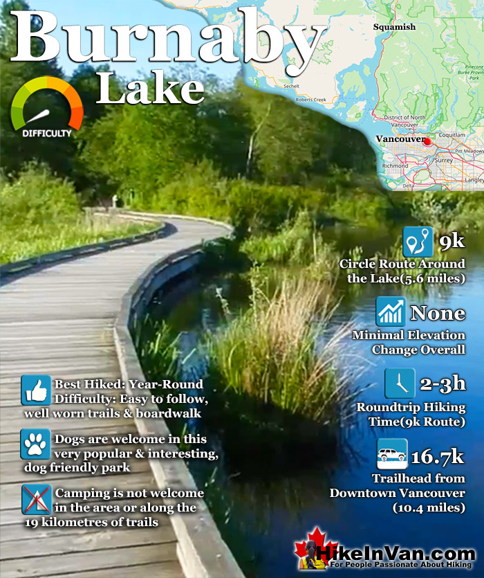
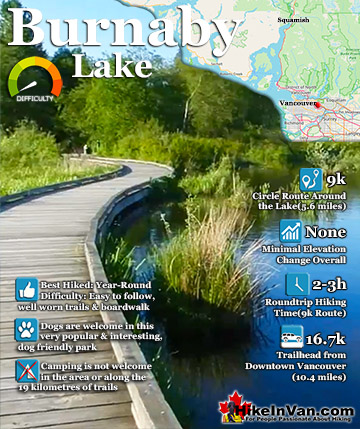
Burnaby Lake Regional Park has a series of trails that add up to 9 kilometres if done in a circular route around the lake. There are in fact 19 kilometres of trails in the park. The various trails include the 2.6 kilometres Cottonwood Trail, the 1.8 kilometres. Brunette Headwaters Trail, the 0.8 kilometres Avalon Trail which connects the Burnaby Equestrian Centre with the Southshore Trail.
The 3.4 kilometres Southshore Trail, and the smaller trails, Conifer Loop, Spruce Trail Loop and the Pavillion Trail. Burnaby Lake is often alive with activity. Whether on the water or around it. Over 400 types of creatures live in the area. Bald eagles, ospreys, herons, beavers and ducks are all frequently seen. Hiking and birdwatching are the main draws to the park, however, canoeing, rowing and kayaking are also done here. The Burnaby Canoe and Kayak Club and the Burnaby Lake Rowing Club practice here quite often. There are several access points to Burnaby Lake Regional Park. The four main access points are the Burnaby Sports Complex entrance, the Glencarin Traiilhead entrance, the Avalon Avenue entrance and the Piper Avenue Entrance.
Directions to Burnaby Lake
The easiest place to start hiking in Burnaby Lake Park is to start at the Nature House on Piper Avenue. From the Lougheed Highway in Burnaby, turn south on Brighton Ave, then right on Winston Ave, then left on Piper Ave.
Explore Vancouver Hiking Trails!
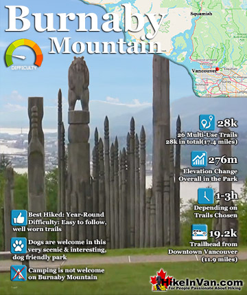
Burnaby Mountain, just 30 minutes east of downtown Vancouver has a nice network of popular trails with fantastic views of Vancouver, Burrard Inlet and beyond. The trails link to the wonderful Trans Canada ...
Burnaby Lake Regional Park has a series of trails that add up to 9 kilometres if done in a circular route around the lake. There are in fact 19 kilometres of trails in the park. The various trails include ...
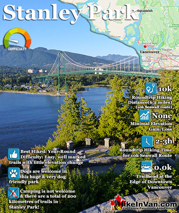
Stanley Park in downtown Vancouver is a beautiful and astoundingly huge network of hiking/walking/biking trails. An estimated 8 million hikers, walkers, rollerbladers and cyclists visit the park yearly. The wonderful ...
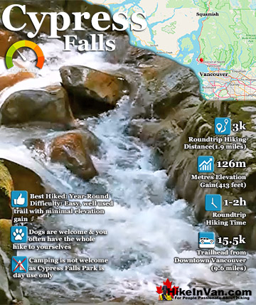
The idyllic Cypress Falls trail has two nice waterfalls to see as well as an impressive forest of old growth cedars and Douglas firs. From the trailhead to the lower falls is easy to follow. There are quite a ...
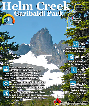
Helm Creek is a cute, meandering creek that winds its way from beyond Black Tusk, down the valley to the wonderful campground that takes its name. From the Helm Creek campground, Helm Creek descends further ...
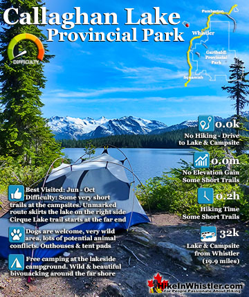
Callaghan Lake Provincial Park is a relatively untouched wilderness of rugged mountainous terrain. The valley walls were formed by relatively recent glaciation. Evidence of this can be seen in the ...
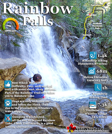
The short, scenic and easy hiking trail to Rainbow Falls is found at the same, much more well known trailhead for Rainbow Lake. The trailhead is marked as the Rainbow Trail and the trail quickly ascends ...
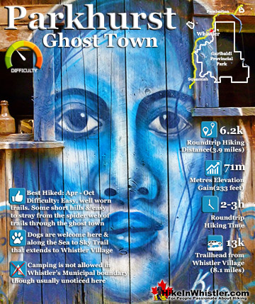
Whistler has an absurd number of wonderful and free hiking trails and Parkhurst Ghost Town certainly ranks as one of the most unusual, exotic and interesting. Parkhurst was a little logging town perched on ...
Whistler is an amazing place to hike. Looking at a map of Whistler you see an extraordinary spider web of hiking trails. Easy trails, moderate trails and challenging hiking trails are all available. Another marvellous thing about Whistler is that Garibaldi Provincial ...
Squamish sits in the midst of some amazing places to hike. Garibaldi Park sprawls from Squamish up and beyond Whistler. Tantalus Provincial Park lays across the valley to the west and the beautiful and desolate, by comparison, Callaghan Valley to the north. Add to ...
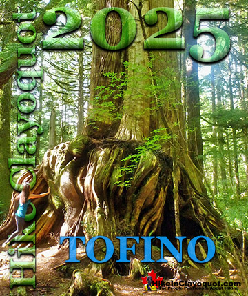
Clayoquot Sound has a staggering array of hiking trails within it. Between Tofino and Ucluelet, Pacific Rim Park has several wilderness and beach trails, each one radically different from the last. The islands in the area are often Provincial parks on their own with ...
Victoria has a seemingly endless number of amazing hiking trails. Most take you to wild and beautiful Pacific Ocean views and others take you to tranquil lakes in beautiful BC Coastal Rainforest wilderness. Regional Parks and Provincial Parks are everywhere you turn ...
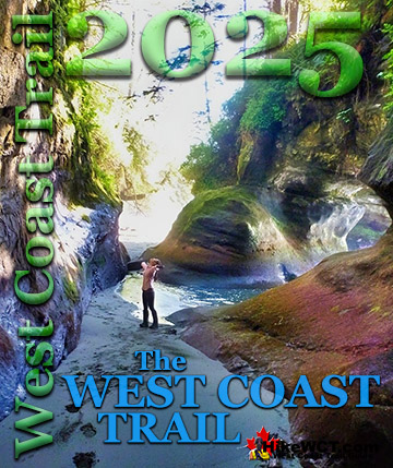
The West Coast Trail was created after decades of brutal and costly shipwrecks occurred along the West Coast of Vancouver Island. One shipwreck in particular was so horrific, tragic and unbelievable that it forced the creation of a trail along the coast, which ...