There are plenty of moderately challenging Vancouver hiking trails to choose from. These are five trails that stand out from the rest. Not too difficult, yet all have sensational views. Hollyburn, Dog Mountain and Mt Seymour are at the end of beautiful drives to reach the trailheads.
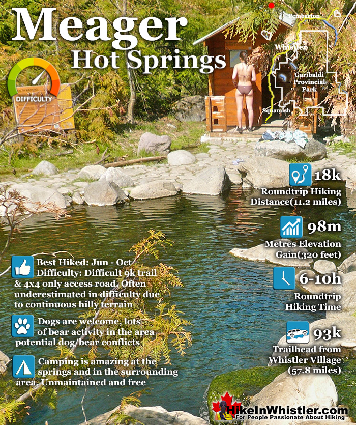
Meager Hot Springs(aka: Meager Creek Hot Springs) is located 93 kilometres northwest of Whistler, was beautifully developed into gorgeous pools, with a caretaker and usage charge. At its height of popularity, Meager Hot Springs had 30,000 yearly visitors. Unfortunately, due to two recent avalanches it seems unlikely to ever officially reopen. After several years of being closed, access reopened on 2009 with a nice, expensive, new bridge.
Only to be dramatically obliterated from another slide in 2010. In 2014 the new VOC Harrison Hut Trail was mostly completed, allowing access to Meager Hot Springs once again. Currently this access road is in a bit of a construction zone, so don't be surprised if the road is blocked by a rock slide or road construction. The old access bridge over the Upper Lillooet River which cost nearly a million dollars was wrecked in seconds in 2010. There was considerable wrangling and negotiating to get it built in in 2009, but now it will almost certainly never be rebuilt. The area is far too active. Access to the springs is now via the new Harrison Trail via the south side of the the Upper Lillooet River, above and beyond the still visible, still awe inspiring, mudslide carnage. With the catastrophic mud and debris slide let loose from Devastator Peak in 2010, the nice new (in 2009) million dollar bridge to the Meager Hot Springs was destroyed. Though destroyed doesn't even begin to describe it. Looking on the now, dead end road, where the bridge once stood, the place still looks a mess. "Meager Creek FSR is closed indefinitely; no access to the hot springs." This is from the BCParks Upper Lillooet Provincial Park site, and evidently quite accurate. Dead and still dying grey ghosts of trees still stand as they did in piles of forest wreckage. Even the road in looks bizarre. The road was simply bulldozed back to life. On either side, hemmed in by piles of dirt and dead trees. In the last couple years BC Ministry of Forests and Recreation Sites and Trails BC have been aggressively blocking public access to both Meager Hot Springs and Keyhole Hot Springs. Currently, in 2023 they have blocked both access roads with gates to the trailheads and are threatening to issue violation tickets. The warning reads: SITE CLOSED: Meager Hot Springs are within Lil̓wat Nation territory. This is a place of cultural and spiritual significance for Lil̓wat Nation. The site closure supports the protection of important cultural, environmental, and wildlife values. The Meager Creek Drainage is prone to extremely large landslides, avalanches, and flooding/washouts. The Province will be enforcing this closure and will issue violation tickets to anyone caught ignoring the restrictions. They don't appear to have any legitimate reasons for the closures and are clearly making up vague things to justify blocking public access. For example: "Mineral licks at the hot springs provide wildlife with year-round nutrients. The hot springs are also home to the vivid dancer damselfly, a species of special concern that is threatened by intensive recreational use. Meager Creek Hot Springs is the only known location within BC where the American bulrush (Schoenoplectus americanus) grows".
The mudslide that did this seems beyond belief. This river valley in the midst of a beautiful, green forest, is a sea of brown. Mud, dirt, and dead trees. At its peak of popularity in 1994, Meager Hot Springs had 30,000 visitors a year. With the unrestrained numbers, vandalism and violence broke out at the springs often so the BC Forest Service stepped in. They hired an on-site supervisor, limited vehicle access and charged a usage fee. Then the big slide of 2010 happened and now of course it only gets a few, very motivated visitors.
In 2014 a new route was built to Meager Hot Springs by the UBC Varsity Outdoor Club. The new VOC Harrison Hut Trail regains access to the much prized Harrison Hut, but also opens up an excellent access trail to Meager. The trail is long and not too easy, however, and getting to the trailhead is quite an adventure. The logging road deteriorates quickly on the last couple kilometres and you find yourself dodging basketball sized boulders strewn across the road. The old access route to Meager ran along the far(north side) of the Lillooet Forest Service Rd. This new trailhead is located on the near(left or south) side of the Upper Lillooet River and you simply continue along the Pemberton Meadows Road (almost) until you can't go any further. From the middle of Pemberton to the trailhead is 64 kilometres. The easy to miss trailhead is marked with a small trailhead sign for "VOC Harrison Hut Trail" No mention of Meager Hot Springs on it.
Explore Whistler Hiking Trails!
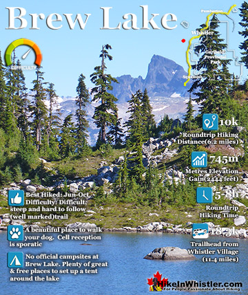
Brew Lake is beautiful mountain lake just a short drive south of Whistler and is relatively unknown and seldom hiked. Laying at the base of Mount Brew, Brew Lake lays in a massive alpine valley of enormous erratics. ...
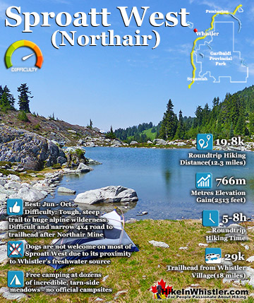
Mount Sproatt, or as it is known locally as just Sproatt, is one of the many towering mountains visible from Whistler Village. Above and beyond Alta Lake, directly across from Whistler Mountain and Blackcomb ...
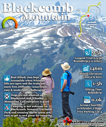
Blackcomb Mountain holds an impressive and ever growing array of hiking trails. From the moment you step off the Blackcomb Gondola and you arrive at the Rendezvous Lodge, you see hiking trails ascend into ...
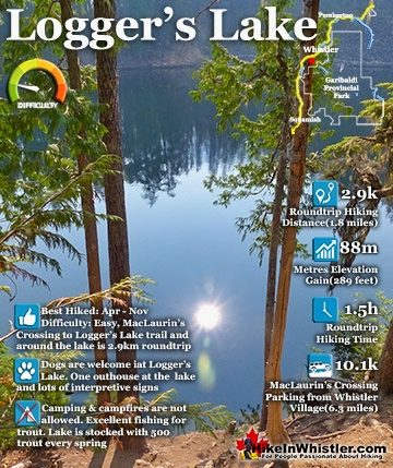
Logger’s Lake is an amazing little lake hidden up in the deep forest above the more well known Cheakamus River. The lake, almost unbelievably exists in a long extinct volcano. However, as soon as you see ...
Whistler is an amazing place to hike. Looking at a map of Whistler you see an extraordinary spider web of hiking trails. Easy trails, moderate trails and challenging hiking trails are all available. Another marvellous thing about Whistler is that Garibaldi Provincial ...
Squamish sits in the midst of some amazing places to hike. Garibaldi Park sprawls from Squamish up and beyond Whistler. Tantalus Provincial Park lays across the valley to the west and the beautiful and desolate, by comparison, Callaghan Valley to the north. Add to ...
Clayoquot Sound has a staggering array of hiking trails within it. Between Tofino and Ucluelet, Pacific Rim Park has several wilderness and beach trails, each one radically different from the last. The islands in the area are often Provincial parks on their own with ...
Victoria has a seemingly endless number of amazing hiking trails. Most take you to wild and beautiful Pacific Ocean views and others take you to tranquil lakes in beautiful BC Coastal Rainforest wilderness. Regional Parks and Provincial Parks are everywhere you turn ...
The West Coast Trail was created after decades of brutal and costly shipwrecks occurred along the West Coast of Vancouver Island. One shipwreck in particular was so horrific, tragic and unbelievable that it forced the creation of a trail along the coast, which ...