There are plenty of moderately challenging Vancouver hiking trails to choose from. These are five trails that stand out from the rest. Not too difficult, yet all have sensational views. Hollyburn, Dog Mountain and Mt Seymour are at the end of beautiful drives to reach the trailheads.
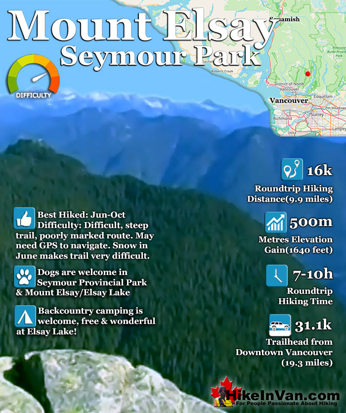
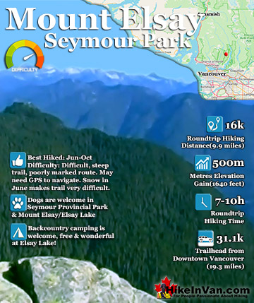
Mount Elsay is a tough 16 kilometre roundtrip hike that takes you beyond Mount Seymour and the crowds into the desolate backcountry of Mount Seymour Provincial Park. To get to the marked Mount Elsay trail you have to follow the trail to Mount Seymour. Mount Elsay is a difficult and dangerous trail to hike if you are unprepared or poorly equipped. The trail is often very difficult and losing the trail is very possible even in good weather.
The trailhead for Mount Seymour (which leads to the Mount Elsay trail) is easy to find once you have reached the main parking lot to Mount Seymour Resort. To get to the main parking lot simply drive until you come to the end of the road and the end of the final parking lot (you will see ski lifts). Looking towards the end of this long parking lot you will see a large, round wooden map board. Walk along the trees. From here on there are frequent tree markers and signs directing you to Mount Seymour. Follow this route until you get to the col between Second Peak and Third Peak where the Elsay Trail starts. The Mount Elsay trail that branches off of the Mount Seymour trail is, at times hard to follow as it descends west of Mount Seymour into the depression between Second Peak and Third Peak. There is a sign "Danger - Steep Terrain". At this sign look left to find flagging tape marking the trail to take to Mount Elsay. This trail will lead along the edge of Mount Seymour and a metal, "Mt Elsay Trail" sign.
The trail then gradually ascends toward the summit of Elsay. At the ridge between the two mountains, Seymour and Elsay the trail forks. Following the rock cairns to the right into the rock field will lead to the Elsay Lake trail which allows for a different route on your way back. To reach Mount Elsay, instead head steeply up, bearing left toward the summit.
From Highway #1 (Trans-Canada Highway) take Exit #22 Mount Seymour Parkway. Turn right onto Mount Seymour Parkway almost immediately and follow it 4.4 km before turning left onto Mount Seymour Road. Follow Mount Seymour Road as it winds it's way up the mountain. Drive to the end of the large parking lot at the end of the road. Start at the Mount Seymour Trail kiosk, to the left of the Mystery Peak chairlift. Parking is free and there are no trail fees in Mount Seymour Provincial Park.
Explore Vancouver Hiking Trails!
Mount Elsay is a tough 16 kilometre roundtrip hike that takes you beyond Mount Seymour and the crowds into the desolate backcountry of Mount Seymour Provincial Park. To get to the marked Mount Elsay trail ...
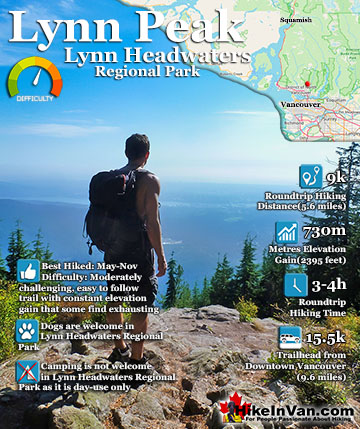
This beautifully forested hiking trail is a local favourite running route comparable to the Grouse Grind. In 4.5k the trail rises 730 metres and hardly ever in a straight line. There are a few good ...
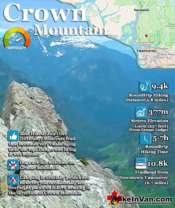
Crown Mountain, visible from downtown Vancouver, towers behind Grouse Mountain. It was appropriately named due to its crown shape over 150 years ago by an English captain charting the area. This very ...
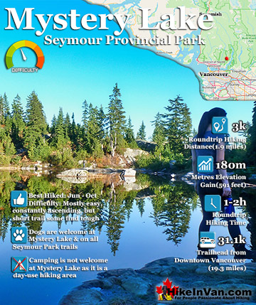
Mystery Lake is an easy, well marked trail that leads to a cute mountain lake that is perfect for relaxing, swimming or having a picnic. It is just 1.5km to the lake and like the rest of Seymour Park, dogs are ...
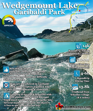
Wedgemount Lake itself is a magnificent destination for a day hike or spectacular overnight beneath the dazzling mountain peaks and stars. Many sleep under the stars on one of the many beautiful tent ...
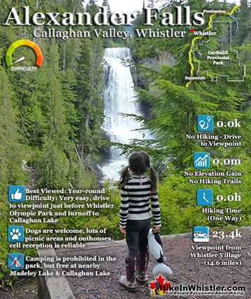
Alexander Falls is a very impressive 43 metre/141foot waterfall just 30 to 40 minutes south of Whistler in the Callaghan Valley. Open year-round and located just before Whistler Olympic Park where several of ...
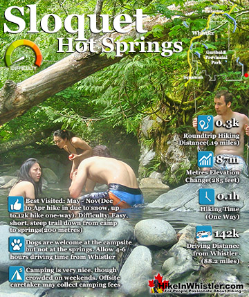
Sloquet Hot Springs is a wonderfully wild set of shallow, man-made pools fed by a small, all natural, and very hot, waterfall. The pools stretch from the waterfall to the large and crashing Sloquet River. ...
Whistler is an amazing place to hike. Looking at a map of Whistler you see an extraordinary spider web of hiking trails. Easy trails, moderate trails and challenging hiking trails are all available. Another marvellous thing about Whistler is that Garibaldi Provincial ...
Squamish sits in the midst of some amazing places to hike. Garibaldi Park sprawls from Squamish up and beyond Whistler. Tantalus Provincial Park lays across the valley to the west and the beautiful and desolate, by comparison, Callaghan Valley to the north. Add to ...
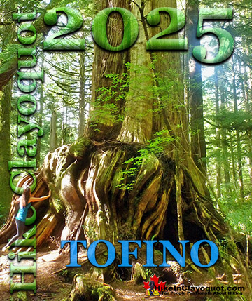
Clayoquot Sound has a staggering array of hiking trails within it. Between Tofino and Ucluelet, Pacific Rim Park has several wilderness and beach trails, each one radically different from the last. The islands in the area are often Provincial parks on their own with ...
Victoria has a seemingly endless number of amazing hiking trails. Most take you to wild and beautiful Pacific Ocean views and others take you to tranquil lakes in beautiful BC Coastal Rainforest wilderness. Regional Parks and Provincial Parks are everywhere you turn ...
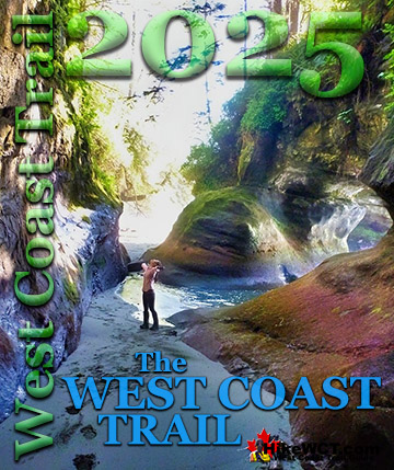
The West Coast Trail was created after decades of brutal and costly shipwrecks occurred along the West Coast of Vancouver Island. One shipwreck in particular was so horrific, tragic and unbelievable that it forced the creation of a trail along the coast, which ...